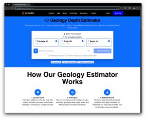
AI Geology Estimator Predicts Well Depths Nationwide -- DrillerDB Launches Tool for U.S. Homeowners and Contractors
DrillerDB’s AI estimates local well depth, water levels, and stratigraphy at any U.S. address -- plain English guidance for faster quotes and site planning.
With our AI Geology Estimator, anyone can get a credible, local starting point for depth and construction planning in minutes, before a rig ever rolls.”
CHICAGO, IL, UNITED STATES, August 26, 2025 /EINPresswire.com/ -- Built on millions of well records, available across the U.S.— Craig Vander Galien
The Geology Estimator draws from DrillerDB’s platform of public well records, standardized and enriched from state and federal sources to model conditions from shallow unconsolidated aquifers to deeper bedrock targets. Users can search an address and within seconds see a full geological analysis of their location. If enough data is not available at the location, the system will fall back to a simple depth estimate. This nationwide coverage pairs naturally with DrillerDB’s Interactive Well Map, giving drillers and homeowners a single place to explore well history, context, and predictions.
What users get in minutes
- Typical well-depth estimate for the immediate area, expressed as a range with a central expectation.
- Expected static water level based on nearby measurements and hydrostratigraphic patterns.
- Recommended drilling method (e.g., rotary mud circulation vs. air rotary) aligned to local materials and depths.
- Layer-by-layer geology profile summarizing the likely stratigraphy (for example, glacial tills and clays over sand/gravel lenses, overlying dolomitic limestone).
These outputs mirror the Geology Estimator available to DrillerDB Subscribers when making customer proposals.
AI where it helps,
DrillerDB has long used AI to extract geology, casing, and water-level details from well-log PDFs and to render professional section diagrams. The new Estimator extends that approach to location-based predictions grounded in evidence: it synthesizes nearby logs, observed lithology transitions, and spatial trends, then explains its result in natural language. The system prioritizes transparency, showing the surrounding wells and their attributes, so drillers can audit the context behind a prediction. It is designed to accelerate early-stage planning, not to replace site-specific engineering judgment or regulatory requirements.
“Surprises underground are what can blow out budgets,” said Craig Vander Galien, Founder & CEO of DrillerDB. “With our AI Geology Estimator, anyone can get a credible, local starting point for depth and construction planning in minutes, before a rig ever rolls. It helps homeowners and builders budget realistically, and it helps drillers quote with confidence backed by data.”
Vander Galien added: “We built this with drillers in mind: clear ranges, practical method suggestions, and a one-click path to the nearby logs that informed the estimate. It’s the context you wish you had on every first phone call.”
Who it’s for
- Homeowners & builders: set realistic budgets, reduce change orders, and understand the ‘why’ behind a quote.
- Drillers & pump contractors: quote faster with local depth, method, and water-level context; export a simple geology summary for customers.
- Engineers & land developers: de-risk site selection and early feasibility with concise stratigraphy overviews.
Designed to fit the way drillers actually work
The Estimator is part of the broader DrillerDB platform: project management, scheduling, field mobile apps, and a nationwide well map. So teams can move from planning → quoting → job execution → documentation without switching systems. A typical workflow: find the location, review the geology estimate, preview nearby logs, generate a preliminary quote with the preferred method and casing assumptions, and hand it off to the field with consistent details.
Availability and roadmap
The AI Geology Estimator is available today on DrillerDB’s Geology Estimator page and integrates directly with the Interactive Well Map for nationwide exploration. Upcoming enhancements will introduce per-site confidence indicators, richer export options (including branded PDFs), and contractor-level controls for preferred methods and default construction assumptions.
Important note: The Estimator provides planning guidance and is not a substitute for stamped engineering, permitting, or compliance with local regulations. Final well design should be confirmed by qualified professionals and aligned with state and county requirements.
About DrillerDB
DrillerDB is a platform built by drillers, for drillers. The company combines project management, a nationwide well-map database, and mobile field apps with geology-aware workflows that help contractors quote accurately, drill efficiently, and document jobs cleanly. DrillerDB maintains nationwide coverage of well records and provides tools for planning, execution, and reporting across drilling and pump/service operations. Learn more at drillerdb.com.
Craig Vander Galien
DrillerDB
+1 920-296-3999
email us here
Visit us on social media:
LinkedIn
Facebook
DrillerDB Geology Estimator Demo Video
Legal Disclaimer:
EIN Presswire provides this news content "as is" without warranty of any kind. We do not accept any responsibility or liability for the accuracy, content, images, videos, licenses, completeness, legality, or reliability of the information contained in this article. If you have any complaints or copyright issues related to this article, kindly contact the author above.

